Golaghat at a glance
 Golaghat, one of the oldest erstwhile subdivision of the northeast
Indian state of Assam, created during the pre-independence era in the year 1848, has
become a full fledged district (139 years later) on 23rd October, 1987.
Golaghat, one of the oldest erstwhile subdivision of the northeast
Indian state of Assam, created during the pre-independence era in the year 1848, has
become a full fledged district (139 years later) on 23rd October, 1987.
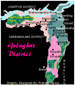
The district comprises of three subdivisions, Golaghat, Dhansiri and Bokakhat. And has a population of over 800,000 according to the Census-1991 report.
Kaziranga National Park, famous for its one-horned Rhino worldwide, and the Nambor reserve forest are the two natural reserves of wild flora and fauna.
Dhansiri, Doyang, Gela-beel and Kakodonga are the main tributaries of the river Brahmaputra that flows across the district.
Tea, sugarcane, rice, mustard, oranges, pineapples are some of the principal cultivated crops.
A major oil refinery is now under construction at Numaligarh. People believe that this will perhaps usher in the much needed industrialization of the predominately residential district.
Geographically, it is situated at a height of 71 metres above sea level near 26 degree North and 94 degree East.
It is bounded by river Brahmaputra in the North, Nagaland state in the South, Jorhat district in the East, and Karbi Anglong and Nagaon districts in the West.
According to old folklore, Golaghat got its name from being a place of business (Gola) near the river port (Ghat) of Dhansiri.
A famous Assamese satirical saying associating Golaghat is showing up a Golaghat-face (the nearest translation I could achieve!) meaning a gloomy, sickly person.
Golaghat at one time was famous (rather infamous) for its frequent outbreaks of Malaria and Kala-Azar. Of course, now these diseases are seldom encountered, but the old saying struck!